When a massive wall of ice and rock detaches from a high-altitude cliff at an elevation of 5,200 meters, it does not merely fall. It unleashes a terrifying chain reaction that can fool even the most sophisticated global monitoring networks.
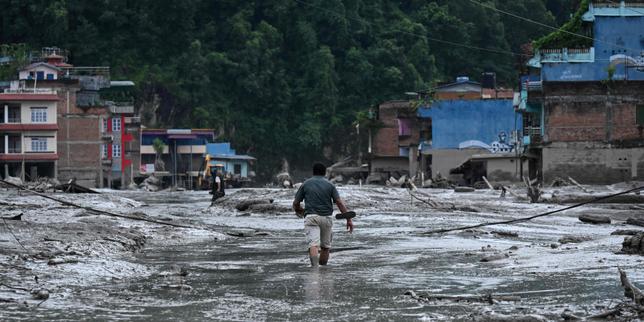
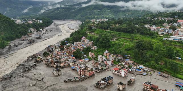
The catastrophic flash floods that struck the Nepal-Tibet border region, killing over 160 people and leaving hundreds more missing along the Bhote Koshi and Lhende river corridors, were initially misidentified by the United States Geological Survey as a magnitude 4.4 tectonic earthquake. Hours later, after analyzing long-period seismic waves, local monitoring stations, and high-resolution satellite imagery, scientists corrected the record. No tectonic fault had ruptured. Instead, a colossal glacial mass had sheared off the mountainside, generating an equivalent magnitude 5.2 seismic signature as millions of tons of debris crashed into the valley floor.
This misdiagnosis highlights a dangerous blind spot in how modern science and local authorities track high-altitude environmental hazards. Mountain glaciers are behaving in ways that defy historical templates, turning the roof of the world into an active zone of compounding ecological failure.
The Mechanics of a High-Altitude Catastrophe
Gravity and thermodynamics dictate these disasters, but human vulnerability transforms them into tragedies.
Geomorphologists studying the event point to an insidious process at the glacial bed. Increased ambient temperatures across the region inject substantial volumes of liquid water into the upper layers of the ice. This meltwater percolates downward through internal fissures until it reaches the bedrock, acting as a pressurized lubricant. Friction drops to near zero. The entire mass of ice and moraine loses its grip on the cliff face and gives way.
When this slurry of ice, mud, and boulders slams into a narrow mountain river like the Lhende Khola, it creates an immediate, temporary dam. Water pools aggressively behind the unstable debris barrier, building immense hydrostatic pressure. Within minutes, the makeshift dam fails. The resulting wall of water surges downstream with explosive velocity, rising as much as nine meters in half an hour and obliterating roads, bridges, and hydropower stations before downstream communities have even processed the initial tremor.
Why Seismic Networks Get It Wrong
Seismometers measure ground motion, distinguishing between different types of energy waves. Tectonic earthquakes release energy through sharp, sudden shearing along a fault line. Large landslides, rock avalanches, and glacial collapses produce a different acoustic and seismic signature, characterized by long-period surface waves and low-frequency rumblings that can closely mimic minor tectonic shifts.
In remote border regions where dense sensor arrays are sparse, automated algorithms lean on default assumptions. When a sudden jolt registers near the Nepal-China frontier, the system flags an earthquake.
This lag between automated detection and accurate physical interpretation costs precious time. Disaster management frameworks built around traditional earthquake protocols fail when the threat originates from melting ice rather than shifting tectonic plates. Early warning systems designed to shut down infrastructure or evacuate valleys seconds after a seismic jolt are useless if the emergency responders are looking for fault lines while an ice-rock avalanche is already barrelling down a gorge.
The Infrastructure Deficit in a Warming Basin
The human toll along the border reveals a stark reality. Himalayan river valleys serve as critical economic conduits, housing vital transport routes and ambitious run-of-the-river hydropower projects that form the backbone of local energy grids.
These installations are engineered to withstand historical flood thresholds, but historical data no longer applies to the Third Pole. The Lhende Khola has flooded multiple times in recent years, signaling a structural shift in regional hydrology. Yet development continues to outpace risk assessment. When the latest surge hit, operating and under-construction hydropower plants were battered, turning industrial infrastructure into secondary hazards as debris choked narrow river channels.
Compounding the physical destruction is the heavy presence of tourists, pilgrims, and local workers traveling through steep, confined terrain. Valleys that funnel trade and spiritual journeys also act as natural death traps when upstream choke points fail. Cross-border communication gaps between Nepal and neighboring jurisdictions further delay coordinated rescue efforts, leaving isolated communities to search for missing loved ones in deep mud and wreckage without immediate support.
The mountains are rewriting the rules of survival, and the margin for error has vanished entirely.