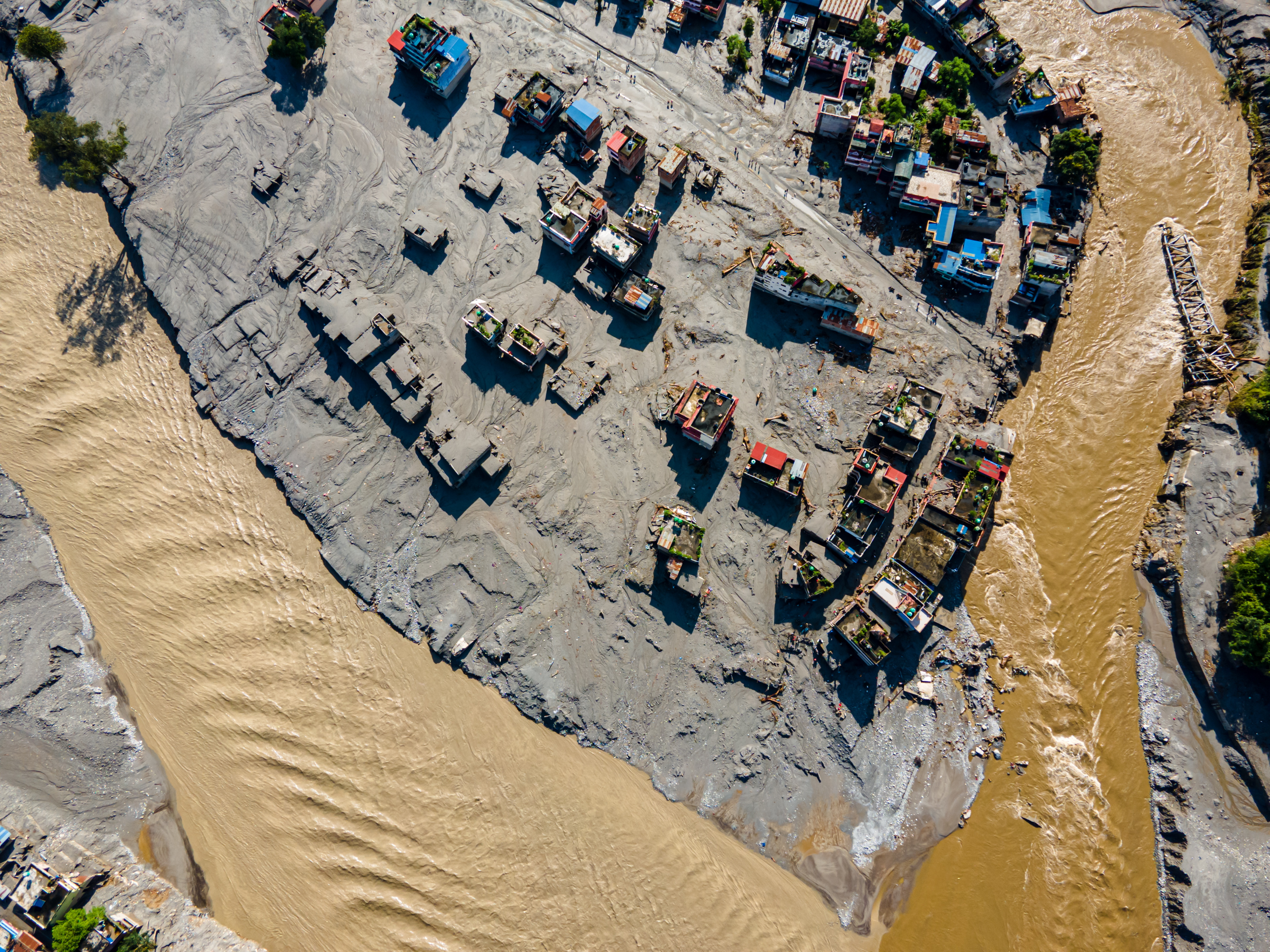
The physical destruction across the Nepal-Tibet border region leaves little room for imagination. When an enormous section of a Himalayan glacier broke loose near Langtang National Park, it sent a high-velocity wall of water, mud, ice, and rock thundering down the Bhotekoshi and Trishuli river valleys. More than 600 people are confirmed dead, thousands remain missing, and towns like Bidur have been reduced to choking fields of grey sludge. Standard news coverage focuses heavily on the immediate human tragedy and the harrowing accounts of survival. Yet stopping at the human cost ignores the systemic mechanics of a disaster that scientists and regional analysts saw coming for decades.
This is not merely a seasonal monsoon accident. It is a structural failure of high-altitude risk management in an era of rapid thermal acceleration.
The Anatomy of a Cryospheric Collapse
To understand why the disaster unfolded with such terrifying speed, one must look above the tree line. The Hindu Kush Himalaya region warms significantly faster than the global average. As atmospheric temperatures climb, glacial ice masses lose mass at an escalating rate, thinning glaciers and destabilizing internal drainage systems. When a massive section of ice shears off, it does not just slide; it acts as a kinetic hammer hitting the valley floor.
The initial impact registered seismic forces equivalent to a moderate earthquake. This impact liquefied saturated debris, creating a dense slurry that bypassed standard early-warning frameworks. Traditional river-gauge systems, designed to measure liquid water increases from heavy rain, proved useless against a viscous wall of boulders and ice traveling at highway speeds. By the time loudspeakers in villages along the corridor crackled with evacuation warnings, the torrent had already breached local choke points.
Decades of decentralized infrastructure development along these fragile corridors compounded the exposure. Hydropower projects, roads, and trade outposts are historically placed in narrow river gorges where flat land is accessible. Planners routinely balance immediate economic yield against geological risk, heavily favoring the former. When the valley floor becomes a high-energy flume, those multi-million-dollar energy corridors and concrete bridges offer zero resistance. Over forty bridges vanished in minutes, and hundreds of megawatts of active generation capacity dropped off the grid, crippling regional power grids just as winter approaches.
The Blind Spots of International Relief
In the wake of the catastrophe, the immediate international response follows a familiar script. Pledges of financial aid arrive alongside specialized rescue units, and media outlets broadcast aerial shots of muddy helicopters touching down at makeshift command posts. But the physical geography of the Himalayas dictates a harsh logistical reality. With over forty kilometers of vital roadway completely erased and treacherous terrain blocking ground access, relief operations rely almost entirely on rotary-wing aircraft.
This bottleneck exposes a critical vulnerability in disaster logistics. Heavy equipment required to clear massive debris-dams cannot be easily airlifted in quantities sufficient to alter the hydrological threat. Furthermore, secondary hazards quickly take precedence over initial rescue phases. Debris dams formed along the upper river channels routinely overflow or experience sudden structural failure days after the initial impact. Rescuers must frequently abandon search zones mid-operation as upstream water levels spike without warning, leaving families waiting on muddy riverbanks for news that may take weeks to arrive.
The demographic profile of the missing also highlights an overlooked policy failure. Alongside local villagers and laborers, hundreds of foreign nationals—tourists, trekkers, and pilgrims visiting sacred high-altitude sites—remained unaccounted for across remote districts. The lack of integrated, mandatory digital tracking for travelers entering ecologically volatile mountain zones turns search-and-rescue operations into guessing games across vast, unmapped wilderness areas.
Moving Past Reactive Sympathy
Governments across South Asia treat these events as isolated acts of nature, distributing temporary relief funds while rebuilding identical infrastructure in the exact same hazardous paths. That approach guarantees future tragedies. True adaptation requires relocating critical trade routes out of steep gorge bottoms, investing in satellite-based cryospheric monitoring rather than downstream water gauges, and enforcing strict zoning laws that acknowledge the permanence of climate transformation. Until regional policymakers treat high-altitude hazard mitigation as a national security priority rather than an environmental footnote, the valleys of the Himalayas will remain countdown timers waiting to expire.